As stated previously in this work, the network’s goal is to segment static objects with a high amount of robustness. With this in mind, the dataset must be large and diverse enough throughout several factors such as location, lighting ,and seasonal variance. This post is a short update on the fist iteration of such a dataset.
Data acquisition
The dataset contains orthophotos covering different areas of Norway. All images came from the Norwegian Mapping Authority, Kartverket, via the University of Oslo. Pictures were taken in spatial resolution of 4 to 20 cm per pixel with three spectral bands RGB. They come from different years (2018 - 20220) and flights. The photo-flying season in Norway begins in April and lasts until the end of September. Therefore the acquired photos are characterized by a wide variety of optical conditions. They include images of different saturation, angles of sunlight, and shadows lengths. Simultaneously, the photos are from varying periods of the vegetation season. It does aid this dataset in providing robustness. However winter-landscapes and other challenging conditions are missing. To provide more diversity in the dataset, 64 map tiles were selected from various locations around all 11 different counties, spanning over 200km².
| No. sheets | Scale | GSD | Height | Width | Area height | Area length | Total size | Drone FOV | Drone height | No. sets |
|---|---|---|---|---|---|---|---|---|---|---|
| 11 | 1:1000 | 4.0 cm | 20000 px | 15000 px | 800 m | 600 m | 9.9 Gb | 20 m | 43 m | 12441 |
| 11 | 1:2000 | 8.0 cm | 20000 px | 15000 px | 1600 m | 1200 m | 9.9 Gb | 41 m | 87 m | 12441 |
| 11 | 1:2000 | 10.0 cm | 16000 px | 12000 px | 1600 m | 1200 m | 6.6 Gb | 51 m | 109 m | 7843 |
| 11 | 1:5000 | 12.5 cm | 25600 px | 19200 px | 3200 m | 2400 m | 11.0 Gb | 64 m | 136 m | 20350 |
| 11 | 1:5000 | 20.0 cm | 16000 px | 12000 px | 3200 m | 2400 m | 6.6 Gb | 102 m | 217 m | 7843 |
NB! Drone field of view (FOV) and height are approximations.
Classes
As mentioned in earlier posts, the images are annotated with two classes: water bodies and buildings. Only roads longer than 50m were available in the vector maps, so they are not usable for this work.
Building
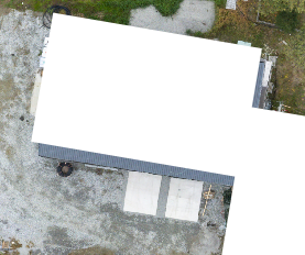
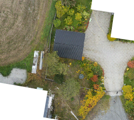
An object standing permanently in one place. RGB(255,255,255)
Water bodies
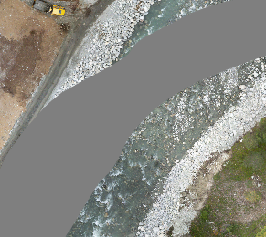
Flowing and stagnant water, including ponds and pools. RGB(127,127,127)
Background
Areas not classified into any class. It can include, e.g., fields, roads, and all objects excluded from above. RGB(0,0,0)
Annotations
The ground truth labels are annotated automatically using the vector maps provided by Kartverket. However, this does provide some issues as the annotations are set per GPS points, and the orthophotos are not always perfectly rectified. Also, water bodies are not always stationary and are prone to poor annotations.
1. Rectification of orthophotos was not perfect; some buildings were not completely segmented.  2. Not all buildings were segmented.
 3. Water segmentation of rivers was highly inaccurate; this is due to the riverbed naturally shifting.
Summary
After cropping sets of images and annotations from the orthophotos and annotations maps, the dataset ended up with 67219 samples at a size of 25,1Gb. However, the dataset is not yet scraped for sets not containing useful classes, erroneous annotations, or missing orthophoto coverage. This is the first Alpha version, and the next iteration will most likely be smaller and hopefully more precise.
